Coria: the Story of Roman Corbridge
From a fort at the crossing of Dere Street and the Tyne to the army's great supply base for Hadrian's Wall and a walled town that lasted into the 5th century: the history of Roman Corbridge, its granaries, fountain and compounds, the excavations that revealed it and the puzzle of its name.
Half a mile west of the Market Place, on a terrace above the Tyne, lies the most northerly town of the Roman Empire that you can still walk through. Visitors to Corbridge Roman Town see a main street, two granaries, a fountain, a huge unfinished courtyard building and a pair of walled military compounds. What they see is the top layer of more than three centuries of history.
This long read tells that story from the first fort to the end of Roman Britain, and explains how archaeologists pieced it together. It draws mainly on English Heritage's published history and research summaries for the site, the Roman Inscriptions of Britain project and the excavation reports listed at the end. Dates for a site like this are argued over, and where the sources differ we say so. For opening times, tickets and what to expect on the day, see our separate guide to visiting Corbridge Roman Town.
Why here? Dere Street and the Stanegate
Roman Corbridge exists because of a river crossing. Dere Street, the main Roman road from York to Scotland, crossed the Tyne here. English Heritage's description of the site notes that the road bridged the river just west of the town and that a second road, the Stanegate, ran west from Corbridge towards Carlisle. Travellers coming from the bridge entered along the main street before turning north towards the frontier.
That junction made Corbridge a natural place for the army to control movement and to store supplies. It also meant that when the army moved on, traders and families stayed. English Heritage's significance assessment puts it simply: the site moved from a sequence of forts, to a supply base, to a town. Of all the places along Hadrian's Wall, it says, only Carlisle had a comparable history, and there the remains lie buried beneath the modern city.
The forts, about AD 77 to 160
Red House and the first fort
The army first established a base not on the present site but at Red House, a little over half a mile to the west. English Heritage dates it to about AD 77 to 83 and links it to the governor Agricola's planned conquest of Scotland.
The first fort on the present site followed. English Heritage dates it to about AD 86; Wikipedia's summary, drawing on older literature, says about AD 84. Wikipedia also suggests that its garrison was probably a cavalry regiment, the Ala Petriana. Both sources agree that this fort was destroyed by fire in about AD 105.
Rebuilding, and the coming of the Wall
A second fort replaced it, and around AD 122 it was modified as Hadrian's Wall was built two and a half miles to the north. Corbridge was never on the Wall itself. It sat behind it on the Stanegate, the earlier frontier road.
When Hadrian's successor, Antoninus Pius, pushed the frontier north to the Antonine Wall around AD 139 to 140, Corbridge became important again as a base on the road into Scotland. English Heritage says the first granaries were under construction in this period, and Wikipedia credits the first stone fort to the governor Lollius Urbicus. When the Antonine Wall was given up, Hadrian's Wall was recommissioned, by about AD 160 according to English Heritage. The great stone bridge that carried Dere Street over the Tyne was probably built about the same time.
English Heritage's significance assessment describes four forts in all, one above another. Little of them is visible today. The side street between the later compounds follows the line of the forts' main street, the via praetoria, and the modern museum building marks the line of the early forts' west rampart.
The supply base, about AD 160 to 211
In the early 160s the fort gave way to something new: a base used by detachments of the legions, the Roman army's heavy infantry. English Heritage records soldiers of the Twentieth and Sixth Legions here. This is when Corbridge began to look like the place that survives.
The granaries
The two granaries on the north side of the main street are, in English Heritage's words, the best-preserved Roman granaries in Britain. Their floors were raised on low walls so that air could circulate beneath them through the vents still visible in the side walls, keeping the grain dry and free of vermin. A portico at the front sheltered carts while they were loaded and unloaded.
The street outside was resurfaced so many times that its level rose by more than the height of the column bases, which ended up buried. English Heritage dates the rebuilding of the granaries to the reign of Septimius Severus, with the west granary built between AD 198 and 209.
The fountain
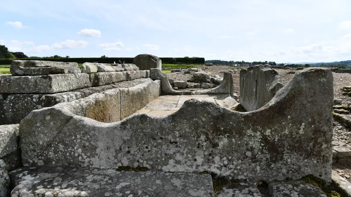
Between the granaries and the large courtyard building stands the fountain house. English Heritage dates it to the late 2nd or early 3rd century. Water was brought to it along an aqueduct carried on an embankment, and fed a long stone trough. The trough's edge is heavily worn. English Heritage attributes that wear to washing, not, as was once popular, to soldiers sharpening their knives on it.
Site XI: the great unfinished building
East of the fountain lies the largest structure on the site, known to archaeologists as Site XI. It measures 67 by 65.5 metres and is built of large blocks with rough, bossed faces, laid without mortar. English Heritage dates it to between about AD 160 and 185. Its wide entrances suggest that it was meant to be a market or storehouse, arranged around a central courtyard.
It was never finished. English Heritage's significance assessment calls it probably the largest single building visible in Roman Britain, and says that its incompleteness is "stark testimony to the troubled state of the northern frontier" in the late 2nd century. Excavators have found a layer of burnt material from the early 180s, known as the "Corbridge destruction deposit". English Heritage notes that a link to a recorded barbarian invasion of the province at about that time has been suggested but not proved.
The legionary compounds
To the south of the main street are two walled compounds. English Heritage's history dates them to the early 3rd century and says they were built for detachments of the Second Legion Augusta and of the Twentieth (or possibly the Sixth) Legion; its description of the site names the Second and the Sixth. Either way, each compound had its own headquarters building, and the two were laid out on a shared visual axis, with temples and other buildings around them.
English Heritage's significance assessment compares this arrangement with Dura Europos in Syria, another frontier town where soldiers lived in walled enclaves among the civilian population.
The northern campaigns of Septimius Severus
Between AD 208 and 211 the emperor Septimius Severus campaigned in Scotland in person. English Heritage describes Corbridge as one of the two main supply bases for that expedition, which explains the investment in its granaries at the end of the 2nd century. After Severus died at York in 211, the frontier settled on Hadrian's Wall for good.
The town, 3rd to 5th centuries
With the army's campaigns over, Corbridge became mainly a civilian town. English Heritage notes that the area now on display, about 1.8 hectares, is only the central part of a town that covered somewhere between 15 and 20 hectares. Most of it lies under the fields around the site.
English Heritage describes it as probably the administrative centre of a local district, a civitas, by the 3rd century, and as prosperous in the 4th, when it was probably walled. One of the most striking pieces of evidence for that prosperity is a large house south-west of the centre, overlooking the river, which had 23 rooms and underfloor heating and was occupied until the end of the 4th century. Its garden fountain used the stone lion that is now the star of the site museum. Our long read on the Corbridge treasures tells its story.
Gods and temples
Corbridge has produced an unusually rich collection of religious sculpture, much of it reused in later buildings. English Heritage notes that many carvings of gods were broken up and reused in a 4th-century repair of the main street, and that the archaeologist Ian Richmond used them in 1943 to reconstruct the cults practised by the legionaries here. The finds include an altar to Jupiter Dolichenus, a god from Syria popular with soldiers, and a relief dedicating a temple to Sol Invictus, the Unconquered Sun. English Heritage's research summary adds a note of caution: some of the buildings identified as temples in the early excavations may in fact have been commercial premises.
The end of Roman Corbridge
How Roman Corbridge ended is one of the open questions about the site, and the sources do not agree. English Heritage's history records road repairs as late as about AD 370, and says the town was rapidly abandoned in the early 5th century, after Roman rule in Britain collapsed. Wikipedia's summary of the archaeology is more cautious, saying that when occupation came to an end is unclear, and English Heritage's own research framework lists it among the questions still to be answered.
What is clear is that, by the time a new community appears in the record, it is not on the Roman site. English Heritage places the 7th-century Anglo-Saxon settlement about half a mile to the east, where the village stands today. By the 670s, Roman stone was being carried away for St Wilfrid's church at Hexham. Our story of Anglo-Saxon Corbridge picks up from there.
Robbed, ploughed and forgotten
For more than a thousand years the Roman town served as a quarry. You can see the results in the village. The tower arch of St Andrew's Church is built from Roman stones, and Roman masonry turns up in older buildings around the Market Place. Our heritage walking trail points them out.
The site was never entirely forgotten. English Heritage records that in 1201 King John had it dug for treasure and found only stones "marked with brass, iron and lead". The antiquaries John Leland, around 1539, and William Camden, in 1599, both saw ruins. By the time John Horsley described the site in the early 18th century it was being ploughed, and English Heritage says the last visible remains were levelled around 1810. In 1861 and 1862 William Coulson excavated the northern end of the Roman bridge.
The great excavations, 1906 to 1914
Systematic excavation began in 1906. According to English Heritage, the original plan was for a five-week dig; the work went on every season until 1914.
The academic lead was Francis Haverfield, the leading Roman historian of his day. Wikipedia records that the first season was supervised by a young Leonard Woolley, who left for Egypt in 1907 and later became famous for excavating Ur. Supervision then passed to R. H. Forster, and the work was run by the Corbridge Excavation Committee, whose president was the Duke of Northumberland. Reports on the work appeared in Archaeologia Aeliana, the journal of the Society of Antiquaries of Newcastle upon Tyne.
English Heritage's account of the excavations also names some of the people behind the work. The Hexham chemist and photographer J. P. Gibson (1838 to 1912) was the excavation's official photographer, and his pictures are an important record of what was found. A labourer, George William Hall, worked through all nine seasons.
The Edwardian excavators worked on a scale no modern archaeologist would attempt, stripping large areas to reveal the plan of the latest Roman buildings. That is why the site looks the way it does today, and also why much of the earlier history had to be worked out later from what survived underneath.
After 1914: training grounds and new questions
Between the wars, Ian Richmond and Eric Birley returned to the central area. In 1933, according to English Heritage, the central part of the site was given to the nation.
From 1947 to 1973 Corbridge hosted annual training excavations, where generations of students learned to dig; Wikipedia notes that Brian Dobson ran them in the 1960s and 1970s. English Heritage says this work was eventually published by Mike Bishop and John Dore in 1988. Those seasons found the wooden chest of armour and tools known as the Corbridge Hoard in 1964, which our treasures long read covers in detail.
The last excavation inside the guardianship area was in 1980, on the site of the new museum. Since then the most important work has been at the river. In 2004, rescue excavation on the southern bank west of the site uncovered the ramp that led up to the Roman bridge, published by Paul Bidwell in 2009. What survives of the bridge, and how its stones were recovered from the river, is told in our long read on the Tyne at Corbridge.
Coria or Corstopitum? The name question
For most of the 20th century the Roman town was known as Corstopitum, and you will still see that name in older books. Today English Heritage and most archaeologists call it Coria. The reasons are worth explaining, because the disagreement is real.
The name Corstopitum comes from the Antonine Itinerary, a Roman list of routes and stopping places, which records a station of that name on the road north. Another form, Corie Lopocarium, appears in the Ravenna Cosmography, a late Roman and early medieval list of places. Both forms are generally regarded as corrupted in copying, and scholars have proposed several reconstructions, including Coriosopitum, Corsopitum and Corsobetum.
The case for Coria comes from the writing tablets found at Vindolanda, a fort a few miles west along the Stanegate. These are letters and documents written by people who actually lived on the frontier around AD 100. The Roman Inscriptions of Britain project notes that a place called Coria appears frequently in them, usually in the form Coris, meaning "at Coria", and that this is almost certainly the Roman name for Corbridge. English Heritage's research summary goes further and calls the form Corstopitum "corrupt", a copyist's error in the Itinerary.
The disagreement is not completely settled. Ian Richmond suggested that the Itinerary's form might reflect an original "Corsopitum", which he interpreted as "reedy portion". English Heritage notes that the Vindolanda tablets give Coria without the tribal name that is sometimes attached to such places, so the full official name may have been longer. English Heritage's visitor material glosses Coria as a Celtic word meaning "hosting place", but that meaning is a modern interpretation, not something the Romans recorded.
Seeing Roman Corbridge today
Almost everything described here can be seen at Corbridge Roman Town, now in the care of English Heritage. The main street, granaries, fountain, Site XI and the two compounds are laid out in the open. The museum on site holds sculpture, inscriptions and finds from the excavations, including the Corbridge Lion and objects from the 1964 hoard.
Our visiting guide covers opening times, getting there on foot from the village and the best order to explore. Pieces of Roman Corbridge are also scattered around the village itself, and our interesting facts about Corbridge and lost buildings of Corbridge guides explore them. To follow the frontier north to the Wall itself, see our guide to Corbridge and Hadrian's Wall country.
Sources and further reading
- English Heritage, History of Corbridge Roman Town, Description, Significance, Research and Extraordinary Explorations at Corbridge.
- Roman Inscriptions of Britain, Corbridge (Coria), on the Roman name and its sources.
- A. L. F. Rivet and C. Smith, The Place-Names of Roman Britain (1979).
- Wikipedia, Coria (Corbridge), used for leads and checked against the sources above.
- M. C. Bishop and J. N. Dore, Corbridge: Excavations of the Roman Fort and Town, 1947 to 80, English Heritage Archaeological Report 8 (1988).
- P. Bidwell, on the 2004 excavation of the Roman bridge approach at Corbridge (2009).
- R. H. Forster, H. H. E. Craster and others, reports on the 1906 to 1914 excavations, Archaeologia Aeliana, 3rd series.
Spotted something we have missed, or know a good source on Roman Corbridge? Get in touch.
Never miss what’s on
Join the weekly CorbridgeVillage.live digest — the best events, news and local tips, straight to your inbox. One email a week.
What's On
Jim Ross Interviewed by LJ Ross
See organiser · Corbridge Community Hub, 19 Princes Street, Corbridge
Tynedale v Chester (National League 2 North)
2:00 PM · Tynedale Park, Station Road, Corbridge NE45 5AY
Remembrance Sunday Civic Service
10:40 AM · St Andrew's Church, Market Place, Corbridge NE45 5AA