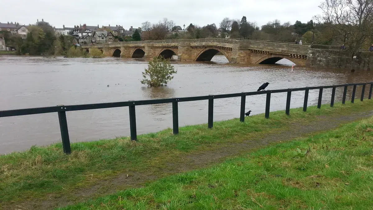
The Tyne at Corbridge: Bridges, Floods and the River
Roman, medieval and 17th-century bridges, the ford they replaced, the Great Flood of 1771 that left Corbridge's bridge standing, Storm Desmond in 2015 and the salmon river of today: the story of Corbridge and the Tyne.
Corbridge exists because of the Tyne. The Romans built here because their great road north, Dere Street, had to cross the river. The medieval town grew around a bridge and a ford. And for 350 years the village has been defined by its 1674 bridge, which survived a flood that destroyed almost every other crossing in the valley.
The river has also been Corbridge's biggest hazard, most recently in December 2015, when Storm Desmond put homes, businesses and sports grounds south of the bridge under water. This long read follows the Tyne at Corbridge through four bridges, two great floods and the return of the salmon. It draws on Historic England's list entry for the bridge, Northumberland's historic environment record (Keys to the Past), Northumberland County Council's flood reports and the other sources listed at the end. Where they disagree, we say so.
The Romans' bridge
The first bridge at Corbridge was Roman. It carried Dere Street over the Tyne just west of the Roman town, the site now known as Corbridge Roman Town. English Heritage thinks the stone bridge was probably built around AD 160, when Hadrian's Wall was brought back into use after the army withdrew from the Antonine Wall in Scotland.
Its remains were visible for centuries. Keys to the Past records that the antiquary John Leland noted them around 1540. Our guide to the lost buildings of Corbridge tells the story of how the bridge was taken apart: in 1840 the agent of Greenwich Hospital, which then owned the Dilston estates across the river, removed stones for building Dilston Mill, and the remnants of the piers that a local historian, W. W. Tomlinson, described in 1888 as standing about three feet high were later demolished.
What archaeologists have found
The Edwardian excavators examined the south side in 1906. Keys to the Past records the foundation of the southern abutment, about 39 feet 6 inches by 22 feet, and a conjectured line of about ten piers, each roughly 15 feet 4 inches by 29 feet. That would have made the bridge about 154 yards long, carrying a road some 20 feet wide.
Much more was learned in the last 30 years, because the river was eating away the remains. An evaluation in 1995 found six piers on the river bed, a ramp and fallen moulded blocks, perhaps from a balustrade and a base for a statue. The northern abutment was not identified.
In 2004 a joint project by Tyne and Wear Museums and English Heritage, funded by the Heritage Lottery Fund, excavated the ramp leading up to the bridge on the south bank before erosion destroyed it. According to Keys to the Past, over 300 blocks were recorded, dismantled and reassembled a short distance from the current river bank. The project concluded that the bridge may have had up to 11 arches and stood about nine metres above the river. A watching brief the following year recorded a revetment and a stone that may have come from an aqueduct.
Sources describing the reassembled stones do not make it clear how accessible they are today. Some walking guides suggest approaching from the village car park on the south side of the river, but check locally before setting off, and keep off the riverbank when the water is high.
The medieval bridge and the ford
After the Romans left, people crossed the Tyne at Corbridge by ford. Keys to the Past records that a bridge was built in 1235 "above the line of the ford", apparently a timber one, and that a bridge existed by 1256, when it is mentioned in the assize rolls. A stone bridge followed. It had a chapel dedicated to St Mary, which received a papal indulgence for repairs in 1401 and was described as ruinous by 1428. Our lost buildings guide has more on the chapel.
Remains of the medieval bridge were still visible in Victorian times. Keys to the Past notes that Tomlinson reported oak tie-beams in the river bed at low water in 1888, although none could be seen by 1956. The medieval bridge eventually failed. The local bridge history site Bridges on the Tyne says that by the 17th century the crossing had reverted to a ford, until the present bridge was built.
The 1674 bridge
The bridge you walk over today was completed in 1674. Historic England lists it at Grade I, its highest grade, and it is also a scheduled monument. The list entry describes it as a bridge of 1674, "southern arch rebuilt 1829, bridge widened 1881".
How many arches it originally had is not entirely clear. Keys to the Past and our own walks guide describe it as a seven-arched bridge. Bridges on the Tyne, quoting older descriptions, says it originally had six spans and that an extra span was added at the south end after the great flood. Historic England's list entry records only that the southern arch was rebuilt in 1829. Keys to the Past says 1829 or 1831, noting that the sources differ.
The bridge has been altered many times since. According to Keys to the Past:
- 1780: a contractor, Stephen Loadus, was engaged to raise the southern approach road and repair the flank walls.
- 1829 or 1831: the southern arch was rebuilt.
- 1880 to 1881: the bridge was widened by about three feet, with parapets carried on corbels.
- 1950: the parapet was raised by one course.
- 1969: a new concrete invert was laid under the arches.
- 1970 to 1971: a temporary steel bridge was put up alongside. It was removed in 1981, after the A69 Corbridge bypass opened in 1977.
The sundial on the bridge has been re-cut and, Keys to the Past says, no longer carries the date 1674.
The Great Flood of 1771
What happened
On 16 and 17 November 1771 the Tyne rose higher than anyone could remember. Accounts summarised by Wikipedia describe a thaw of early snow in the Pennines, a cloudburst and days of continuous rain. The flood swept down the North Tyne, the South Tyne and the main river.
The damage was enormous. Wikipedia, drawing on contemporary accounts, records that 13 or 14 bridges were destroyed across the Tyne system and that 25 people died. Most of the village of Styford, on the north bank downstream from Corbridge, was destroyed. At Newcastle, the medieval Tyne Bridge, which had houses and shops built on it, lost its middle arch and two arches near the Gateshead end. The flood also damaged bridges on the Wear at Durham and flooded Yarm on the Tees.
An account of the flood reproduced on the local history blog The History of Newcastle lists the bridges lost upstream, including those at Alston, Ridley Hall, Haydon, Chollerford and Hexham. Hexham's new seven-arched bridge, finished only the year before, was "totally demolished". The same account says that "the only bridge upon the river Tyne which was left standing was that at Corbridge".
Was Corbridge really the only survivor?
It depends how you count. Historic England's list entry says the Corbridge bridge was "the only bridge in Tynedale to survive the great flood of 1771", and Keys to the Past agrees. Some popular accounts, including Wikipedia's article on the flood, go further and call it the only bridge on the Tyne to survive. Strictly, the bridge at Newcastle was badly damaged rather than swept away completely, so Historic England's more careful wording, Tynedale, is the safer claim.
Hands in the river
A story often told about the flood is that the water rose so high at Corbridge that people stood on the bridge and washed their hands in the river. Bridges on the Tyne traces it to W. J. Palmer's The Tyne and its Tributaries, published in 1882, more than a century after the flood. It makes a vivid picture of how close the bridge came to going under, but it is a later tradition, not a recorded eyewitness account, and should be read as such.
That account also claims the bridge stood "on the old Roman foundation", and Bridges on the Tyne says it is "reputed" to have Roman foundations. That is a tradition too: the Roman bridge stood some distance upstream, to the west, and its remains have been excavated there.
Storm Desmond, December 2015
For more than two centuries 1771 was the benchmark. Then, on 5 and 6 December 2015, Storm Desmond fell on an already saturated catchment. Northumberland County Council's report on the winter's flooding says it produced flows "not observed in the River Tyne since 1771". The Environment Agency issued two Severe Flood Warnings, its highest category, for the River Tyne at Corbridge and Wellbank Riverside.
What happened in Corbridge
The council's flood investigation report for Corbridge records the details. The flood defences were overtopped and 43 homes and 12 businesses were flooded internally, along with two other buildings. Most of the flooding was on the south side of the river. Some families had to be rescued from upper floors, and the caravan park was badly damaged.
The report includes a map of the flood prepared by Ed Rollason of Durham University, which traces how the water moved:
- the river overtopped the flood wall west of Dilston Haugh;
- the cemetery wall was damaged and gravestones were uprooted;
- water flowed across the Stanners and into the ground of Corbridge Cricket Club, where it reached 1 to 1.5 metres and left a tide mark on the changing rooms;
- it flowed through the rugby club, home of Tynedale RFC;
- the Station Road roundabout disappeared under water;
- three properties on Well Bank were affected.
Surface water lingered on Station Road into January. The council's winter report records that Storms Eva and Frank brought further flooding across Northumberland in the weeks that followed.
Earlier floods and the response
Corbridge had flooded before. The investigation report notes that in 2005 flooding was caused by the collapse of the flood embankment, which the Environment Agency had since rebuilt. In 2015, by contrast, the defences held but were overtopped.
After Desmond, the Environment Agency carried out temporary repairs to the defences, modelled the effect of gravel building up in the river and proposed removing vegetation from a gravel island in the river. A Corbridge Flood Action Group was set up, and Northumbrian Water looked at how the maximum water level at Kielder Reservoir was managed.
The river gauge at Bywell, a few miles downstream, recorded a record or near-record peak on 5 December. Sources differ on the peak flow: the gauge's own figures give about 1,450 cubic metres a second, while later hydrological studies give higher estimates. All agree it was an exceptional flood.
The salmon river
The Tyne is now one of the best salmon rivers in England, which would have astonished anglers in the middle of the 20th century. Industrial pollution on the lower river had done the salmon great damage. One angling source claims that no salmon at all were caught on the rod in 1959, although we have not been able to confirm that figure from an official record.
Recovery came with the cleaning of the river in the late 20th century, helped by an unexpected source. When Kielder Reservoir was built at the head of the North Tyne, it cut off about 7 per cent of the Tyne catchment, including some of its best spawning streams. To make up for the loss, the Kielder Salmon Centre was set up in 1978 to rear young fish for release. In its 40th year the government reported that the centre had released about 360,000 salmon and 20,000 sea trout, and described the Tyne as "one of the best salmon rivers in the country".
Fishing on the main Tyne around Corbridge is privately managed, with beats let to anglers, such as the Styford beat between Corbridge and Bywell. If you want to fish, check who controls the water and buy the right permit, as well as a national rod licence from the Environment Agency.
The river today: walking by the Tyne
The best way to see the Tyne at Corbridge is on foot, and our guide to walks around Corbridge gives routes with sources. In brief:
- The bridge itself: cross from Princes Street to the south side for the classic view of the arches and the village.
- The floodbank towards Dilston: from the south end of the bridge, a path runs along the top of the flood defence towards the point where the Devil's Water joins the Tyne. It passes close to the Dilston estates, whose story we tell in our long read on the Earls of Derwentwater, and it is a short step to Dilston Physic Garden.
- Upstream to the Roman town: from the north end of the bridge a riverside path heads west towards Corbridge Roman Town, close to where Dere Street once crossed the river.
The free Corbridge Village Car Park sits at the south end of the bridge, and Corbridge station is a short walk from it.
Respect the river
The Tyne at Corbridge is wide, fast and prone to sudden rises, especially after rain or snowmelt in the Pennines. The floodbank path is on the low-lying side of the river and floods first. Check the Environment Agency's flood warnings for the Tyne before you go, avoid the riverbank when the river is high and never try to cross the river on foot.
Sources and further reading
- Historic England, Corbridge Bridge, list entry 1044808 (listed building) and list entry 1006574 (scheduled monument).
- Keys to the Past (Northumberland historic environment record), Corbridge Bridge, N8987 and Corbridge Roman bridge, N9022.
- English Heritage, History of Corbridge Roman Town.
- Bridges on the Tyne, Corbridge Bridge, quoting W. J. Palmer, The Tyne and its Tributaries (1882).
- Wikipedia, Great Flood of 1771, used for leads and checked where possible.
- The History of Newcastle, "The Great Flood of 1771".
- Northumberland County Council, Corbridge Flood Investigation Report (2016) and Winter 2015 Flood Report.
- Environment Agency, "Busy 40th year for Kielder Salmon Centre", GOV.UK.
- W. W. Tomlinson, Comprehensive Guide to the County of Northumberland (1888).
Remember the 2015 flood, or have old photographs of the river at Corbridge? Get in touch.
Local businesses mentioned
Corbridge Roman Town
Corchester Lane, Corbridge, Northumberland, NE45 5NT
Corbridge Cricket Club
The Stanners, Corbridge, Northumberland, NE45 5BA
Tynedale RFC
Tynedale Park, Station Road, Corbridge, Northumberland, NE45 5AY
Dilston Physic Garden
Dilston Physic Garden, Corbridge, Northumberland, NE45 5QZ
Never miss what’s on
Join the weekly CorbridgeVillage.live digest — the best events, news and local tips, straight to your inbox. One email a week.
What's On
Jim Ross Interviewed by LJ Ross
See organiser · Corbridge Community Hub, 19 Princes Street, Corbridge
Tynedale v Chester (National League 2 North)
2:00 PM · Tynedale Park, Station Road, Corbridge NE45 5AY
Remembrance Sunday Civic Service
10:40 AM · St Andrew's Church, Market Place, Corbridge NE45 5AA